Quick answer: Dhanushkodi is an abandoned town and beach at the south-eastern tip of Pamban Island, about 20 km from Rameswaram in Tamil Nadu. It was destroyed by a cyclone on the night of 22–23 December 1964 and has been a ghost town ever since; today a road runs through it to Arichal Munai, the point closest to Sri Lanka. October to March is the most comfortable time to visit. There is no confirmed entry fee, but police close the area when the sea is rough, so check locally before you set out.
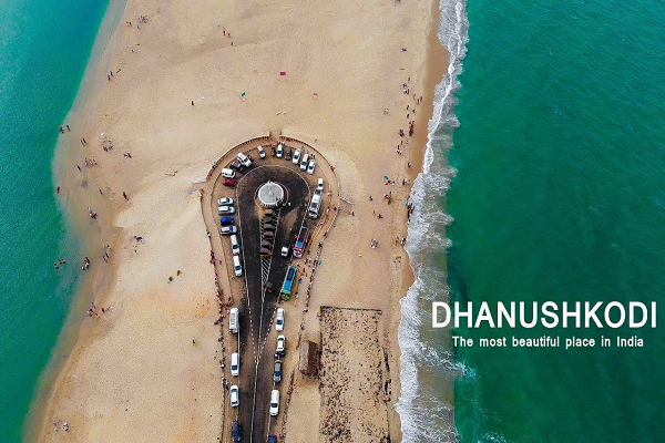
Dhanushkodi, sometimes called the “lost town” of Tamil Nadu, is a long, narrow strip of sand between two seas: the Palk Strait and Bay of Bengal side to the north, and the Gulf of Mannar, which opens to the Indian Ocean, to the south. Sri Lanka’s Talaimannar is only about 24 km away across the water. The bare landscape, clear water and the ruins of the old town make it one of the most striking places on India’s coast.
Dhanushkodi at a glance
| Location | South-eastern tip of Pamban (Rameswaram) Island, Ramanathapuram district, Tamil Nadu |
|---|---|
| Distance | About 20 km from Rameswaram town; about 24 km from Talaimannar, Sri Lanka |
| Known for | 1964 cyclone ruins, Arichal Munai (land’s end), Ram Setu (Adam’s Bridge) views |
| Best time to visit | October to March; go early in the day |
| Time needed | Half a day, combined with Rameswaram |
| Timings and entry | No fixed timings or fee confirmed on an official source; police may close access during rough seas |
History: the 1964 cyclone and the ghost town
Dhanushkodi was once a busy port town. The Boat Mail train ran from the mainland across the Pamban Bridge to Dhanushkodi, where passengers boarded ferries to Talaimannar in what was then Ceylon. On the night of 22–23 December 1964, a severe cyclone struck. An estimated 1,800 people died, including 115 passengers on the Pamban–Dhanushkodi passenger train, which was swept away. The town was wrecked, and the Government of Madras later declared it unfit for living.
The ruins of the railway station, a church and other buildings still stand in the sand, and parts of the old railway line lie buried along the shore. Walking among them is the main reason many people visit.
An earlier version of this article said the cyclone killed “more than a thousand” people and that the government ordered that no one may go to the beach after 6 pm because of “paranormal activity”. The estimated toll is about 1,800. We found no official order about paranormal activity; there is also no official evening cut-off that we could confirm, although local travel guides advise leaving well before dark and police do close the area in bad weather.
What to see at Dhanushkodi
The ruins of the old town
The church, railway station and other ruins are the main attraction. They are exposed to wind and salt, so do not climb on the walls.
Arichal Munai (land’s end)
Beyond the ruins, the road continues to Arichal Munai, where the land narrows to a point with water on both sides. A monument topped by the Ashoka emblem, India’s national symbol, stands at the end of the road, and from here you look out towards Adam’s Bridge and Sri Lanka. Mobile phones set to roam sometimes pick up a Sri Lankan network here, so check your settings.
Where the two seas meet
At Dhanushkodi you can see the calmer Palk Bay side and the more open Gulf of Mannar side on either side of the sand spit. On many days the two waters look different in colour and wave pattern, which makes for good photographs. An earlier version of this article described this as the meeting of “the Indian Ocean and the Bay of Bengal”; more precisely, the island separates the Palk Strait (and the Bay of Bengal beyond it) from the Gulf of Mannar.
Ram Setu (Adam’s Bridge)
Adam’s Bridge, also called Ram Setu, is a chain of limestone shoals about 48 km long that runs from Dhanushkodi to Mannar Island in Sri Lanka, in water that is mostly only 1 to 3 metres deep. In the Ramayana, Lord Rama’s army of vanaras builds a bridge to Lanka to rescue Sita, and many Hindus believe Ram Setu is that bridge; one local tradition links the name Dhanushkodi (“end of the bow”) to this story.
An earlier version of this article said that NASA satellite pictures show a bridge under the water. NASA has stated that images from orbit cannot tell us the origin or age of a chain of islands, so its photos do not show whether the formation is man-made. The Archaeological Survey of India has reported no evidence that it is anything other than a natural formation.
The beach
The beach is long, open and largely undeveloped, with few buildings and fine sand. Do not treat it as a swimming beach: we could not confirm any lifeguard cover, conditions change quickly, and police have barred visitors entirely during swell-surge alerts. Paddle only on calm days and keep children close.
Places nearby on Rameswaram Island
- Pamban Bridge: the old Pamban rail bridge, opened on 24 February 1914, was India’s first sea bridge. It was badly damaged in the 1964 cyclone and was restored in 46 days by a team led by engineer E. Sreedharan. Rail traffic on the old bridge was stopped on 23 December 2022 because of corrosion, and the new Pamban vertical-lift rail bridge opened on 6 April 2025. A road bridge alongside has carried traffic since 1988.
- Rameswaram: one of India’s major pilgrimage towns, with many temples and shrines.
- Gulf of Mannar Marine National Park: 21 small islands and their coral reefs between Thoothukudi (Tuticorin) and Dhanushkodi. Public access inside the park is limited to glass-bottom boat rides.
An earlier version of this article called the Pamban Bridge India’s “second-longest sea bridge” and said it was rebuilt in 48 days. The restoration took 46 days, and with newer, longer sea bridges built since, the “second-longest” claim has been removed.
How to reach Dhanushkodi
- By train: Rameswaram (station code RMM) is the nearest railway station. Trains to Rameswaram resumed in April 2025 when the new Pamban rail bridge opened, and services from Chennai (Tambaram) and other cities now run to the island. Check current trains on the National Train Enquiry System (enquiry.indianrail.gov.in) or IRCTC, because some services were affected by station redevelopment work.
- By road: a road to Dhanushkodi from Mukundarayar Chathiram was completed in 2016, and it continues to Arichal Munai. From Rameswaram, take a taxi, an auto-rickshaw or a local bus. Before the road was built, visitors had to walk or take jeeps along the sand.
- By air: the nearest major airport is Madurai; continue by road or rail to Rameswaram.
There is no railway to Dhanushkodi itself. The old metre-gauge line was destroyed in 1964, and proposals for a new line from Rameswaram have been discussed for years.
Tips for visiting Dhanushkodi
- Start early: sunrise is beautiful and the light is softer; it is also cooler and less crowded.
- Carry water, a hat and sunscreen: there is little shade and few facilities.
- Check the weather: during strong winds or rough seas, especially in the monsoon months, police may close the road.
- Leave before dark: the area is remote and unlit.
- Respect the ruins: they are fragile, and the site is a memorial to those who died in 1964.
For other beaches on India’s east coast, see our guides to Puri Beach in Odisha and Yarada Beach in Visakhapatnam, or explore the famous temples in Chennai on the way.
Frequently asked questions
Why is Dhanushkodi called a ghost town?
Because it was abandoned after a cyclone destroyed it on the night of 22–23 December 1964, killing an estimated 1,800 people. The Government of Madras declared it unfit for living, and the ruins remain.
How far is Dhanushkodi from Sri Lanka?
About 24 km from Talaimannar on Sri Lanka’s Mannar Island.
Can you swim at Dhanushkodi Beach?
It is not a designated swimming beach and we could not confirm lifeguard cover. Paddle only on calm days, and follow police instructions; the area is closed during rough-sea alerts.
Is there a train to Dhanushkodi?
No. The nearest station is Rameswaram, about 20 km away. From there, go by road.
What is the best time to visit Dhanushkodi?
October to March, early in the morning.
Details checked in October 2026 against published histories of Dhanushkodi and the 1964 cyclone, Pamban Bridge and railway records, NASA and Archaeological Survey of India statements on Adam’s Bridge, and news reports on the reopening of rail services to Rameswaram. Access can be closed in bad weather, so check locally before you go.